New Dawn – World's Most Unusual Magazine

Tag: Lemuria

  • Lemuria in Australia & the Pacific

    Lemuria in Australia & the Pacific

    From New Dawn 95 (Mar-Apr 2006)

    The most important questions we can ask are about ourselves, not only as individuals, but as a species. Where did we come from? How did we get here? A question that has bedevilled us for as long as we can remember is: Where and when did we take the step from savagery to civilisation?

    Mainstream historians, who write our textbooks, insist they know: in Mesopotamia, about 5500 years ago. But they are contradicted by places like Chatal Hueyuek, a 13-hectare condominium village that flourished as part of a much broader urban centre in central Turkey, 15 centuries earlier. More ancient still, archaeologists excavated a nine-metre-high, stone castle in the Near East, at Jerico, that is a 1000 years older. The sophisticated level of construction at Chatal Hueyuek, Jerico, and similar, pre-fourth millennium BCE sites proves they were not the first of their kind, but must have developed from much older precursors. Just who were these precursors, and how far back into prehistory did they lay the foundation for all subsequent civilisations, including our own?

    This was the question that sparked more than ten years of concerted research and world travel. I found clues left behind by the long-dead ‘Cliff-Dwellers’ of the American Southwest; among the living oral traditions of Polynesia, Micronesia, Melanesia, Australia, and New Zealand; and in the pre-Buddhist temples of Japan and Southeast Asia.

    The accumulated evidence compelled me to conclude that mankind’s first civilisation gradually arose in the Pacific around 50,000 years. This period coincided with the Upper Paleolithic, or Late Stone Age, famous for its cave-art in southwestern France, and lowered sea-levels, allowing for occupation of Australia by exposed land-bridges. For the next 38,000 years of relative peace and isolation, the Pacific islanders developed the scientific and spiritual arts to high degrees of sophistication through close observance of natural law.

    Their country was known as Mu, the “Motherland,” less a specific geographical territory, than a people and culture spread out over many lands from what is now west-coastal America, throughout Oceania, to Japan. The inhabitants were “Lemurians,” or the residents of sea-girt Mu. Although they venerated numerous deities, the Sun personified the literal and spiritual Enlightenment of a Compassionate Intelligence that ordered the Universe, and attached the eternity of the human soul to recurring patterns evidenced in the cycles of nature.

    The Motherland itself was mostly a low-lying, tropical country, much of it close to the equator, and therefore beset by a hot climate. Her population lived in small fishing villages or on farms. Cities were not unknown, but more ceremonial than urban centres. Step-pyramids, temples, plazas and other examples of sacred architecture, many oriented to various positions of the Sun, adorned the verdant landscape. Lemuria’s prolonged civilised idyll lasted until 12,000 years ago, when the last Ice Age came to an end, causing dynamic increases in sea-level. Much, but not all, of Mu was inundated, and large numbers of its inhabitants fled to the Americas and Asia, where the Jomon Culture arose in Japan.

    Lemurian refugees and their descendants migrated across China and the then-fertile Gobi Desert region. But Mu recovered from the Late Pleistocene devastation, and her people spent the next 69 centuries elevating their scientific spirituality to levels of achievement still unsurpassed, particularly in monumental construction and what would today be referred to as the development of “psychic powers,” still known throughout Polynesia as mana.

    In 3100 BCE, however, an aberrant comet passed near the Earth, provoking a global catastrophe. The lands of Mu were severely effected, and some slipped beneath the sea. Many immigrants escaped to South America, superseding a previous Lemurian colonisation of Pacific coastal Peru. The troublesome comet returned less than a thousand years later to unleash a bombardment of meteoritic material. Mu suffered, but endured, then revived yet again. Her agricultural engineers transformed the high hills of the Philippines into mountainous rice terraces, making Luzon the breadbasket of the Pacific.

    Then, in 1628 BCE, major volcanism and violent seismicity spawned by a final, cometary pass, afflicted the South Central Pacific. Most of the lands of Mu dropped beneath the sea, or were depopulated by hundred-foot-high tsunamis. With her ceremonial centres toppled, and infrastructure shattered beyond repair, the survivors abandoned what was left of their broken Motherland. Their arrival in other parts of the world acted as powerful stimuli for the beginning of new societies, forming the basis of new civilisations in Asia and America. The lost Motherland was subsequently remembered by numerous names – Rutas, Haiviki, Baralku, etc. – by the various peoples who shared in the Lemurian experience.

    During the eighth century BCE, early or proto-Romans began celebrating the annual Lemuria festival to mollify the restless spirits (lemures) of their ancestors. Four hundred years later, the Lemurian domination of Japan ended with the collapse of the Jomon Culture and the arrival of a Mongoloid people from Korea. They found the islands already inhabited by Caucasian indigenes, the degenerated descendants of once-civilised Lemurians. As recently as the early 19th century, the last Lemurians were exterminated by Polynesians in the Poike Ditch Massacre at Easter Island.

    Later that same century, English scientist, Philip Lutley Sclater, postulated the former existence of Lemuria to explain the occurrence of early primates on either side of the Indian Ocean. His contemporary, the German biologist, Ernst Haeckel, concluded that mankind first evolved in Lemuria. But the first popular discussion of the Pacific Motherland was not published until 1926, by British Army Colonel James M. Churchward. His Lost Continent of Mu, based on a translation of ancient tablets purporting to describe the drowned civilisation, ignited a controversy that persists to this day.

    Dismissed by most readers as a fantasy at best or a fabrication at worst, it found credibility 60 years later, when Kihachiro Aratake found a monumental building under water near Yonaguni, southernmost of the Japanese Ryukyu Islands. Its discovery was followed by at least a dozen other sunken structures observed off the shores of Japan, Taiwan, Pompei, Fiji, Peru and North America. This story, as incredible as it may appear to mainstream scholars, was not invented, but emerged entirely from an immense body of evidence, including related folk traditions, archaeological remains and artefacts, geology, and genetics.

    If Mu really existed and the natural catastrophe that destroyed her actually took place, we should expect at least something of this drama to have left its mark in Australia and New Zealand. Indeed, a people who never knew the written word, yet preserved a vivid knowledge of the Lemurian disaster, are the Australian Aboriginals. They tell of Mu-Mu-Na, the flaming rainbow serpent, also known as Mu-It, that fell from heaven to cause a world flood. When recounting the story, even today, Aboriginals swing a bull-roarer named after their mythic rendering of the deluge-inducing comet, because it imitates the fearsome sound produced by the falling “rainbow-serpent.” Their narrations often include descriptions of an ancestral paradise before it sank beneath the sea, remembered as Baralku.

    New Zealand’s Maori tell of a priest who prayed for salvation from a great celestial flame that threatened to incinerate the world when it was still new. His prayers were answered with a colossal flood that quenched all the fires, but wiped out a once splendid kingdom, killing most of its inhabitants. Australian Aborigines believe the tenets of their “Dream-time” cult arrived from the “land of Perfection” before it was engulfed by the sea. In Mangaian myth, Ru was the god of Avaiki, the undersea palace of the dead, and creator of an island at the centre of the world, Rangi-motia, yet another name for the sunken civilisation.

    The noted 19th century anthropologist Abraham Fornander researched a “Polynesian legend from Raiatea Society group, which states that the Deluge was occasioned by the wrath of Rua-Haku (‘Rua, the Lord’), the great ocean-god of that group.” The Deluge itself was known as Te tai o Rua-tapu after its flood-hero, Rua-tapa, in pre-Christian New Zealand. He was a legendary craftsman from Avaiki, who taught the Maori ancestors the art of woodcarving. Churchward’s statement that “the word tau (ta-oo) is one of the few of the Motherland that has been handed down” appears borne out in Hora-nui-a-Tau, “the Great Out-Stretched Land of Tau,” and Hau-papa-nui-a-Tau, “the Hilly Land of Tau.” In Maori folk tradition, these were the homelands from which the Tangata-Whenua, the original inhabitants of New Zealand, arrived in the ancient past.

    The Lemuria glyph symbolising their homeland was configured into a “T,” and pronounced ta-oo, identical to tau in the Greek alphabet. The same T-glyph is repeated in Aboriginal bark painting. It encloses seven sparkling figures corresponding to the Pleiades. Aboriginal myth recalls that the constellation belonged to a group of spirits, the Muramura, which combines the names of the sunken Motherland with that of the sun-god, Ra. They created human beings by smoothing out the limbs of unformed beasts, then gave them the first rites of initiation into sacred mysteries. The Muramura were said to have travelled over the world before being drawn up into the night sky by a long hair cord. Their name (a contraction of Mu, the Motherland, and the ‘Egyptian’ sun-god, Ra), function as creators of human life, and world-travellers, emphasising their Lemurian identity.

    The Hawaiians referred to the same constellation by the provocative name of Humu. Their tau-shaped “Cross of God” was known as the ta-ha-oo. Nearly 3000 miles from Hawaii, a colossal pyramidal platform, the Tauhala, stands in Mu’a, an ancient port-city on the Polynesian island of Tonga. These self-evidently Lemurian names spread across the vast ocean from Australia to Hawaii are invariably connected to enduring traditions of a lost homeland destroyed by an awesome act of nature.

    The Maoris believed that Te-Tumu was the ‘source’ which gave birth to mankind in the land of Mataaho, known in the Marquesas’ Deluge-chant, Tai-Toko, as Matahou. Sometime thereafter, it was overwhelmed by a killer-wave which some ancestral survivors escaped by sailing a great “canoe” called the Takitumu, “in remembrance of the original home they came from,” according to the ‘Travels of Tamatea’, an indigenous New Zealand chant transcribed in the late 19th century. It also mentions a place called Muri-wai-hou, a submarine realm reigned over by Limu, the god and guardian of the dead, from his vast palace in the depths of the sea. The chant describes the lost country of Irihia:

    “It was a great home of the Maori people, and in it was situated the whare-kura (or temple of learning) of Rongo-marae-roa. It was from this land that men and tribes dispersed to the islands of the great ocean.”

    Numerous oral traditions such as these have been confirmed by regional geologic evidence, which defines the three natural catastrophes that decimated Lemuria before 3000 BCE, around 2100 BCE, and in 1628 BCE. A submerged forest near Wellington in Hutt Valley, New Zealand, dated to circa 3100 BCE, shows a good correspondence with the similar submerged forest deposits of this age in western Europe. Along the west coast of Australia, a prominent ‘fresh’ submerged beach platform has been noted by divers at a depth of three to four meters below sea-level, which has also been tentatively dated to about 5000 years ago.

    American investigator Kenneth Caroli states that “the last known mega-tsunami in the Indian Ocean hit western Australia around 2000 B.C.” William Jett, a US anthropologist, says there was “severe climate change in Asia about 2100 B.C.”
    Get the issue this article appears in

    The outstanding volcanic event of 1628 BCE, the final destruction of Mu, was a blast produced by New Zealand’s Taupo Valley centre. Says Caroli, “the Taupo volcanic zone is quite large, about two hundred fifty kilometres long by forty to fifty kilometres wide, encompassing more than just New Zealand’s north island. It is also broken down into sub-regions. Via carbon-14 dating, it could be exactly contemporary with Akiachak, in Alaska.” It generated a 200-foot high wall of water travelling several hundred miles per hour like an all-encompassing shock-wave throughout the entire Pacific Ocean. Islands standing in its way were overwhelmed and utterly swept clean of every obstruction. Whole archipelagos vanished or were depopulated. Others abruptly sank beneath the surface of the ocean in accompanying earthquakes.
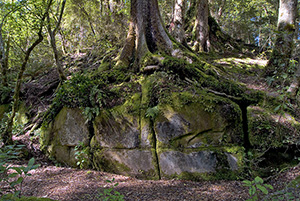
    Section of the Kaimanawa ‘Wall’

    Despite the trans-Pacific devastation of these natural catastrophes, the physical remains of Lemurian civilisation in New Zealand still exist. Immediately south of Lake Taupo, the Kaimanawa ‘Wall’ is more probably a step-pyramid or terraced, ceremonial marae of immense proportions. The American maverick archaeologist, David Hatcher Childress, who investigated the site in 1996, observed that “the blocks seem to be a standard 1.8 meters long by 1.5 meters high. The bottom block runs straight down to 1.7 meters and beyond. The blocks run for twenty five meters in a straight line from east to west and the wall faces due north. The wall consists of approximately ten regular blocks that are seemingly cut and fitted together without mortar.”

    The Lemurian impact on New Zealand and Australia was profound. And as more evidence emerges to confirm the ancient oral traditions of its native inhabitants, mankind gradually realises that our civilised origins are far more profound, technologically and spiritually greater than we have been led to believe.

    [alert type=”general” dismiss=”no”]This article was published in New Dawn 95.[/alert]

    [alert type=”success” dismiss=”no”]If you appreciate this article, please consider subscribing to help maintain this website.[/alert]

    © New Dawn Magazine and the respective author.
    For our reproduction notice, click here.
  • Mysterious Celtic Mummies of the Gobi

    Mysterious Celtic Mummies of the Gobi

    The discovery of Caucasoid mummies in China shows that East and West have been meeting since the Bronze Age. Do they validate some of our most ancient legends?

    Christopher Columbus is said to have been the first to break down the barrier that was the Atlantic Ocean, that massive body of water separating two continents. But such a physical obstruction never existed between Europe and the East – one could always travel over land. The discovery of Caucasoid mummies in China provides not only indisputable evidence ‘Europeans’ travelled to the far East thousands of years before anyone imagined, it has also created controversy.

    At the beginning of the 20th century, the likes of Sven Hedin, Albert von Le Coq and Sir Aurel Stein travelled to the East in search of ancient civilisations, hoping to reach the then forbidden city of Lhasa, the capital of Tibet, and its ruler, the Dalai Lama. On their travels to this almost mythical region, they stumbled upon many ancient ruins and on occasion spoke about the discoveries of desiccated bodies.

    In 1907, the Russian explorer Pyotr Kuzmich Koslov (1863-1935) actually reached Lhasa and met the Dalai Lama. Afterwards, he organised further expeditions and excavated Khara Khoto, a Tangut city founded in 1032 that had been ruined by the Ming Chinese in 1372. Koslov unearthed a tomb fifty feet below the ruins and found the body of a woman, apparently a queen, accompanied by various sceptres, wrought in gold and other metals. Though Koslov took numerous photographs that were published in American Weekly, he was not allowed to disturb or remove anything from the tomb, which was sealed again. His last expedition to Mongolia and Tibet occurred from 1923 to 1926 and resulted in the discovery of Xiongnu royal burials at Noin-Ula.

    Mu & Lemuria

    When news of such discoveries were reported back in the West, it ignited a wide interest in the mysteries of the East, which even today remain largely beyond the reach of most tourists. It were in these remote regions that James Churchward (1851-1936) claimed he had found evidence of a lost civilisation: Mu. For Churchward, Mu was a lost civilisation and continent in the East, which he estimated was 50,000 years old and once the home of 64 million inhabitants. Though Mu once stretched from Micronesia in the West to Easter Island and Hawaii in the Pacific Ocean, knowledge – if not descendants – of Mankind’s original homeland could possibly be found in India and surrounding regions. Churchward believed that the primary colony of Mu was the Great Uyghur Empire, Khara Khoto being its ancient capital, and the civilisation was at its height around 15,000 BCE. Check any encyclopaedia and you will find Churchward ‘borrowed’ that name from the historical Uyghur, who today live primarily in the Xinjiang Uyghur Autonomous Region of China.

    Churchward’s Mu was not too different from Madame Blavatsky’s Lemuria, and it was the American Theosophist Gottfried de Purucker (1874-1942) who published his thoughts on Blavatsky’s doctrine in 1937. He argued that this region, this “enormous tract of country, most of it desert waste,” was once fertile and lush with cities, and that it was here one would “find the seat from which we came as a racial stock,” which was the “Fifth Root Race.” Blavatsky described the fifth root race as such:

    The Aryan races, for instance, now varying from dark brown, almost black, red-brown-yellow, down to the whitest creamy colour, are yet all of one and the same stock – the Fifth Root-Race – and spring from one single progenitor, […] who is said to have lived over 18,000,000 years ago, and also 850,000 years ago – at the time of the sinking of the last remnants of the great continent of Atlantis.

    Later, the French author Robert Charroux (1909-1978) wrote that the Gobi Desert had Magi, or sages of the East, surpassing in wisdom even those resident in Tibet. Stories go that these cities once had ocean ports, and Edgar Cayce even argued that a “City of Gold” will be discovered in the Gobi Desert, including a temple with elevators and electric cars. Others have seen this region as the homeland of those ancient UFOs, the vimanas.

    Taklamakan Desert Gives Up Its Secrets

    But whereas the Gobi Desert might still hold some secrets, it is the Taklamakan Desert that has provided us with revelations. The Taklamakan Desert is a large sandy expanse, part of the Tarim Basin, a region roughly between Tibet and Mongolia, in western China, and crossed at its northern and southern edge by the Silk Road. Conditions are so harsh that travellers avoided the desert as much as possible, but in millennia gone by the region was populated and habitable – very much like de Purucker argued.

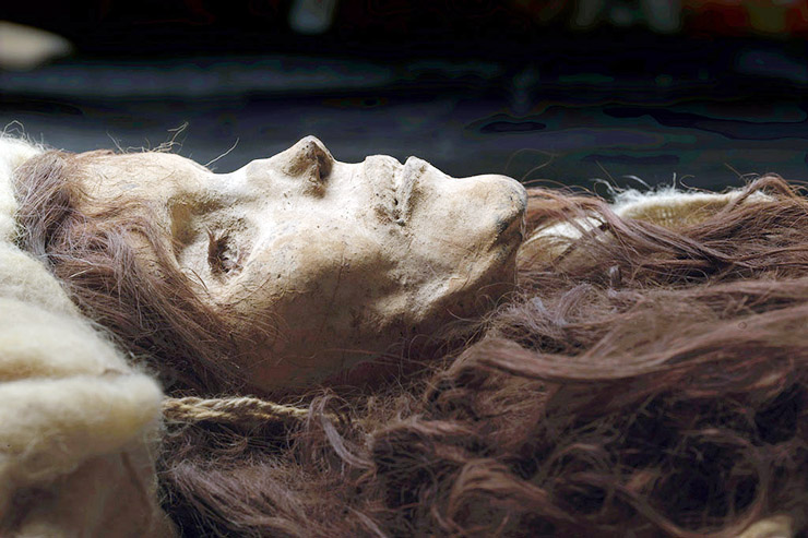
    In recent decades, however, the south east section of the desert, on the edge of Gobi, has become an oasis for archaeologists and historians, as it is here that hundreds of Caucasoid mummies have been found. The most notable mummies are the tall, red-haired “Cherchen man” (dated to ca. 1000 BCE), the “Hami Mummy” (c. 1400-­800 BCE) and the “Witches of Subeshi” (4th or 3rd century BCE), who received their name because of the tall pointed hats they wore. However, the oldest mummy of all is the “Loulan Beauty” (1800 BCE).

    Though not the oldest, one of the most famous mummies of the Taklamakan Desert is that of “Cherchen Man” (see photo in PDF version). His body was placed in a poplar-wood box, lowered into narrow shaft grave, and left for eternity. The climatic circumstances that make this region so inhospitable today preserved these corpses over the millennia, turning them into mummies.

    Cherchen Man is six feet tall, was around fifty years old at the time of his death, has reddish brown hair, a long nose, full lips and a ginger beard. He was buried in a red twill tunic and tartan leggings, and his body is far better preserved than any Egyptian mummy. Most interestingly, Cherchen Man too was buried with no less than ten hats, one of which looks Roman, another looking like a beret, a cap, and even a conical “witch” hat – something commonly found with many of the mummies. His body dates back to 1000 BCE and he looks like a Bronze Age European. In fact, he’s every inch a Celt. Even his DNA says so.

    Next to him were found the mummies of three women and a baby. One of the women is dressed in a red gown, wearing tall boots, her hair brushed and braided. She has a red yarn through her ear lobes and – like the man – has several tattoos on her face. All mummies were painted with a yellow substance, believed to help in the preservation of the body. The baby, probably 3-4 months old, is wrapped in brown blankets, tied with blue and red cord, with a blue stone placed on each eye (see photo in PDF version).

    The oldest of the mummies is the 4,000 year old “Loulan Beauty,” (see photo in PDF version) a mummy discovered in 1980 in an ancient Chinese garrison town located by Sven Hedin in 1900. The town is near the Lop Nor marshes on the north-eastern edge of the Lop Desert. Hedin recovered many manuscripts that state the culture was wiped out by a large seismic occurrence which drastically changed the climate of the area and turned it into a desert. But that was several millennia after the Loulan Beauty lived. This female mummy has long, fair hair. Aged 45 when she died, the Loulan Beauty was buried with a basket of food containing domesticated wheat, combs and a feather. No doubt, these nourishments were for the afterlife.

    She is not the lone ‘European’ to have lived here in those days: the cemetery at Yanbulaq contained no less than 29 mummies that date from 1800-500 BCE, 21 of which are Caucasoid. Best preserved of all the corpses is “Yingpan Man,” who is also known as “the Handsome Man,” a two metres tall 2,000 year old Caucasian mummy discovered in 1995. His blond bearded face was covered with a gold foil death mask, which is a Greek tradition; he also wore elaborate golden embroidered red and maroon wool garments with images of fighting Greeks or Romans. His head rests on a pillow in the shape of a crowing cockerel.

    Elsewhere in the Tarim Basin, hundreds of other mummies have been found, with the earliest ones being genetically Caucausoid or Europoid. Some of the mummies are thought to have been sacrificial victims. A young woman was found partially dismembered, her eyes gouged out. A baby boy had apparently been buried alive. The question remains whether the latter was sacrificial, or he was merely buried with his dead mother.

    How did Europeans End up in the Tarim Basin over 4,000 years ago?

    Although their location is certainly an intriguing one, interest in these mummies exists largely because they are ‘out of place’ relics. Not only does DNA evidence show that the earliest arrivals were from Europe, analyses such as the weave of the cloth reveal it was identical to those found on the bodies of salt miners in Austria, dating from 1300 BCE. The wooden combs buried in Asia are also identical to those found in Celtic countries. So are the stone structures on top of their burial sites – similar to the dolmens of western Europe.

    Despite such certainties, archaeologists and historians have struggled to fill in the ‘soft evidence’ – which are nevertheless the most important questions: how did they get to China, and why did they go?

    We know about these early European visitors to the Tarim Basin largely thanks to the work of Dr. Victor Mair, a professor of Chinese Studies at the University of Pennsylvania. His fascination began when he toured the Urumchi Museum where some of the mummies are displayed. He then invited Dr. Elizabeth W. Barber of Occidental College (California) to visit the mummies and give her expert opinion on the weaving of their clothes.

    “From around 1800 BCE, the earliest mummies in the Tarim Basin were exclusively Caucausoid, or Europoid,” says Mair. East Asian migrants arrived in the eastern portions of the Tarim Basin about 3,000 years ago, while the Uyghur peoples arrived after the collapse of the Orkon Uyghur Kingdom, based in modern-day Mongolia, around the year 842.

    Mair has also stated:

    The new finds are also forcing a reexamination of old Chinese books that describe historical or legendary figures of great height, with deep-set blue or green eyes, long noses, full beards, and red or blond hair. Scholars have traditionally scoffed at these accounts, but it now seems that they may be accurate. (http://en.wikipedia.org/wiki/Tarim_mummies)

    In short, Mair leaves little doubt that we are confronted with a ‘lost civilisation’ of a group of European settlers in a region millennia before any historical accounts were recorded.

    Mair believes that early Europeans headed in different directions, some travelling west to become the Celts in Britain and Ireland, others taking a northern route to become the Germanic tribes, and then another offshoot heading east and ending up in Xinjiang. His team suggests they may have arrived in the region by way of the forbidding Pamir Mountains about 5,000 years ago.

    His opinions tally with those of textile expert Barber, who in her book The Mummies of Ürümchi examined the tartan-style cloth and concluded that the garments can be traced back to Anatolia and the Caucasus, the steppe area north of the Black Sea. She argues this group of people divided, starting in the Caucasus and then splitting, one group going west and another east – confirming Mair’s opinion.

    So, what do we know about these people? We know they were horsemen and herders using chariots, and may have invented the stirrup. We know they had arrived in this region by 1800 BCE. That around 1200 BCE, they were joined by another wave of Caucasoid immigrants from what is now Iran (the so-called Saka branch).

    In fact, the Saka nomads had high-pointed hats – like the ones found next to Cherchen Man – as displayed on the Persepolis reliefs in southern Iran. A bronze statue found in the Altai Mountains from the 5th century BCE has a similar hat. Most important is the fact that the statue has Caucasoid features, and shows similarities in dress to Cherchen Man. It is therefore clear that apart from ‘hard’ DNA evidence, there is other incontrovertible evidence of an early European presence in China. The discovery of the mummies indeed rewrites history.

    When Sir Thomas Douglas Forsyth reported on his 1875 mission to the region, he stated many of the people were tall, fair-faced, with light eyes, sandy whiskers and hair. He added they “only require to be put into coat and trousers to pass, so far as outward appearance goes, for the fairest Englishman.” Two millennia before, Pliny the Elder in “Taprobane” wrote about the Seres, which were described to the Roman Emperor Claudius by an embassy from Taprobane (Ceylon). He said they “exceeded the ordinary human height, had flaxen hair, and blue eyes,” a description which comes close to those people living in the Tarim Basin. Pliny the Elder also said they had an “uncouth sort of noise by way of talking, having no language of their own for the purpose of communicating their thoughts.”

    Political Controversy

    Though no texts have been found in relation to the Tarim mummies, it is now accepted these emigrants spoke a language known as Tocharian (the Chinese called them Yuezhi), that proved to be close to the languages of western Europe. Today, the region‘s inhabitants are the Uyghur people. With their light-coloured skin and hair, many Uyghur‘s are obviously of mixed genetic ancestry, and this fact has a political dimension.

    If one were to find evidence of a Bronze Age seafarer in America, it would obviously create controversy. The discovery of the ‘European’ mummies on Chinese soil also has major political implications. The region is rife with separatist movements and the government fears that promoting a truly unique archaeological find might result in serious social and political unrest. This is one of the main reasons why the Terracotta Army is far more famous than the Tarim mummies!

    Social unrest is greatest between the Uyghur and the Han Chinese. In their drive to lay claim to the region, the Loulan Beauty was even raised to the status of racial icon by the Uyghur, who call her “mother of the nation” – without little supporting evidence.

    The Chinese historian Ji Xianlin, writing a preface to Ancient Corpses of Xinjiang by Wang Binghua, says that China “supported and admired” research by foreign experts into the mummies – i.e. Mair and Barber.

    “However, within China a small group of ethnic separatists have taken advantage of this opportunity to stir up trouble and are acting like buffoons. Some of them have even styled themselves the descendants of these ancient ‘white people’ with the aim of dividing the motherland. But these perverse acts will not succeed,” Ji writes.

    In comparing the DNA of the mummies to that of the modern day Uyghur, Mair’s team found some genetic similarities with the mummies, but “no direct links.” The fact of the matter is that neither the Uyghur nor the Han Chinese seem to be directly related to these ancient settlers – and that both are modern additions to, and admixtures in, a region populated millennia earlier.

    What the discoveries suggest is that both immigrants and modern local Chinese are a mixture of races. “While it is clear that the early inhabitants of the Tarim Basin were primarily Caucasoids,” Mair has written, “it is equally clear that they did not all belong to a single homogeneous group. Rather, they represent a variety of peoples who seem to have connections with many far-flung parts of the Eurasian land mass for more than two millennia.”

    He adds: “Modern DNA and ancient DNA show that Uyghurs, Kazaks, Kyrgyzs, the peoples of central Asia are all mixed Caucasian and East Asian. The modern and ancient DNA tell the same story.”

    Furthermore, a National Geographic study of the DNA of the mummies suggests the Tarim Basin was continually inhabited from 2000 BCE to 300 BCE and preliminary results indicated the people, rather than having a single origin, originated from Europe, Mesopotamia, India and other regions yet to be determined.

    It underlines, once again, that ethnic groups, whether ancient or modern, are genetically a mixture of many races.

    The Formation of the Silk Road

    What brought ‘Europeans’ to the Tarim Basin over 3,800 years ago? The southern Taklamakan Desert is an area where the Silk Road once flourished and prosperous cities were built. In Khotan, two large rivers were channelled, creating an oasis that grew wheat, rice, corn, cotton, grapes, peaches and melons, and irrigated fields for the grazing of sheep. It is clear that life must have been good in those days, and our ancient adventurers had everything they could want. However, because of gradual climate change, the cities were eventually abandoned and subsequently eroded and buried by the dunes.

    The Silk Road was an ancient caravan route connecting China to the West. The Caucasoid mummies in this part of the world suggest the trade route is older than previously thought – very much like transoceanic contact might be several millennia older than Columbus’ first voyage to America.

    The Silk Road was not just a conduit for silk; many other products were transported and traded and the routes were not merely travelled by merchants, but anyone wanting to go East – or West. The routes should therefore be seen as the ancient ‘highways’ between China and the Mediterranean Sea.

    Trading between the East and West occurred from the dawn of civilisation – if not before. Between 6000 and 4000 BCE, people in the Sahara were already importing domesticated animals from Asia. By 3000 BCE, lapis lazuli – the only known source of which was Badakshan, in northeastern Afghanistan – was found in Egypt. Most specifically, the supply of Tarim Basin jade to China from ancient times is well established. Nephrite jade from mines in the region of Yarkand and Khotan – not too far from the lapis lazuli mines of Badakshan – was found in China. Xinru Liu writes:

    It is well known that ancient Chinese rulers had a strong attachment to jade. All of the jade items excavated from the tomb of Fuhao of the Shang dynasty, more than 750 pieces, were from Khotan in modern Xinjiang. As early as the mid-first millennium [BCE] the Yuezhi [Indo-European people] engaged in the jade trade, of which the major consumers were the rulers of agricultural China. (http://en.wikipedia.org/wiki/Tarim_mummies)

    The Tarim mummies overturn the idea that the West and the East developed independently and they only recently started to interact. As Dr. Mair notes,

    I do believe that there is a growing mountain of hard evidence which indicates indubitably that the whole of Eurasia was culturally and technologically interconnected.

    An interesting question is did the Celts go east – or did a Caucasoid group of people, perhaps native to the Tarim Basin, go to Europe? Turning the path of travel in the opposite direction could offer confirmation of speculation this region was an ancient ‘homeland’ that spread to other regions – specifically Europe.

    With so little known about Bronze Age Celts both in Europe and Asia, no firm conclusions can be drawn either way – and perhaps never will. However, the Book of Manu (also known as the Laws of Manu), one of the supplementary arms of the Vedas, states that the “Uyghurs had settlements on the northern and eastern shores of the Caspian Sea” and German anthropologist Max Muller (1823-1900) wrote that “the first Caucasians were a small company from the mountains of Central Asia.”

    These conclusions are obviously ‘old’ – but are they therefore erroneous? Written more than a century before the Tarim mummies were discovered, they actually speak of the presence of Caucasians in China. And if they got that right, is it possible they got other things right too?

    Only future discoveries are likely to tell. But at least it’s an undeniable fact there was contact between Bronze Age Caucasians and East Asians along the Silk Road. The evidence is for all to see in the Urumchi Museum.

    [alert type=”general” dismiss=”no”]This article was published in New Dawn 112.[/alert]

    [alert type=”success” dismiss=”no”]If you appreciate this article, please consider subscribing to help maintain this website.[/alert]

    © New Dawn Magazine and the respective author.
    For our reproduction notice, click here.
  • Mankind’s Cradle of Civilisation Found in Java?

    Mankind’s Cradle of Civilisation Found in Java?

    “Men fear time,” the old saying used to go, “but time fears the Sphinx.” That famous statue and Egypt’s Great Pyramid before which it has reclined for thousands of years have been long regarded as the most ancient monumental structures on Earth. Indeed, their late 20th century reappraisals indicated that they were even older than suspected.

    Beginning in 1974, a medical physicist and colleague of Albert Einstein, Kurt Mendelssohn, showed that the Great Pyramid was not the 2560 BCE tomb of some vainglorious king described by mainstream scholars.1 Instead, the “Mountain of Ra” was raised nearly six centuries earlier, at the very outset of Pharaonic Civilisation, as a massive public works project to unify the numerous, divisive tribes of the Nile Delta in the common cause of its construction.

    So too, the Great Sphinx – roughly contemporaneous, according to Egyptologists, with the Great Pyramid – has been back-dated to at least 5000 BCE – two millennia before the first Egyptian dynasty – by an American geologist at Boston University. During the early 1990s, Robert M. Schoch found that erosion on the Sphinx was not caused by the effects of wind-driven sand, as consensus opinion held, but by moving water, when conditions at the Nile Valley were far more rainy, long prior to the 26th century BCE.2

    As recently as 2009, these extreme chronological disclosures were radically eclipsed by radiocarbon testing of a monumental ceremonial centre in southern Turkey. Its T-shaped pillars, arranged in concentric, stone circles emblazoned with anthropomorphic, zoomorphic and geometric bas-relief images, pushed the start of civilisation back to eleven thousand years ago. But now, even Gobekli Tepe’s primacy has been overtaken by the announcement last autumn of a much larger megalithic complex, half a world away from Anatolia, two thousand or more years older.

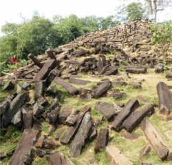
    The paradigm-shattering ruins were found in western Java, fifty kilometres southwest of Cianjur, a city with more than two million residents; Jakarta lies one hundred twenty kilometres to the northwest. A half-hour drive over asphalt and unpaved roads to the village of Karyamukti passes through mountainous landscape dotted with rice paddies and farms flourishing in the volcanic soil with chillies, peanuts, pineapple and corn, then skirts an immense tea plantation. At Mount Padang, hardy visitors need about twenty minutes to climb some 370 stone steps, rising at almost a forty-degree angle, ninety-five metres to the summit, which is crowned with the largest megalithic site in southeastern Asia. It encompasses more than twenty-five hectares, including nine hundred square metres of five, rectangular, stone courtyards ascending northwest to southeast, precisely laid out on a series of landscaped terraces, and neatly organised into low walls, inner partitions, and outward gateways, all of them connected by flights of stairs.

    Within and without the enclosures are dozens of standing monoliths, but many more lie scattered about. The entire complex comprises an estimated 3,703,700 black, andesite blocks ranging from one to two metres in length, and formed by geological processes into polygonal structures of five-, six- or eight-sided columns. (Andesite is an extrusive, igneous rock, a type of basalt formed by volcanic action.) Average dimensions for the columns are 0.3-by-0.3-by-1.5 metres. These smooth-sided blocks weigh from ninety to six hundred kilograms, with an average, individual weight of about three hundred kilograms. In other words, the site’s prehistoric workers transported approximately 1,111,110,000 kilograms (1,224,790 short tons) of building materials 885 metres above sea level, up the precipitous slopes of Mount Padang. Added to their burden was a non-local source for their andesite, which had to be brought in from some distant quarry unknown to academic scholars.

    Archaeologists were further surprised to find traces of a kind of adhesive, glue or perhaps cement that bound some of the top courses of the walls. Beneath, investigators were perplexed by the presence of several layers of sand that had been deliberately incorporated into the original stonework by the prehistoric engineers, perhaps allowing the blocks to move and slide against each other with the motion of seismic disturbances, instead of rigidly resisting such geologic upheavals and breaking under tension. Here was possible evidence for ancient earthquake-proof construction. Java is notorious for its tectonic violence, which claimed the lives of about eighty victims as recently as 2 September 2009. But it seemed utterly inconceivable that some pre-industrial people living in a remote, Indonesian backwater could have actually applied a form of technology our modern world has only recently begun to grasp.

    ‘Musical’ Rocks

    Contributing to the stones’ high strangeness, most of them possess an unusual quality that may have additionally warranted their distant importation by the ancient builders to the top of Mount Padang. Most of its andesite blocks and columns resonate with a bell-like tone when struck with another hard object. They belong to a rare, geological occurrence known as lithophony, the property of some rocks to emit musical sounds under percussive stress. Although only slightly more than one dozen lithophonic boulder fields have been identified in the world, most are found on private property, or have been obliterated by urban development.

    Two, separate sites identically named “Ringing Rocks Park” may be visited in the United States at Upper Black Eddy and Lower Pottsgrove Township, or Stony Garden on the northern slope of Haycock Mountain, all in Pennsylvania. Yet another American “Ringing Rocks” field is found in Montana’s Deerlodge National Forest, on the southwestern flank of Dry Mountain, in Jefferson County, southeast of Butte. Australia has its own “Ringing Rocks” in northwest Queensland, and Mexico’s Cerro de las Campanas, or “Hill of the Bells,” is located on a hill in the city of Querétaro. There are the Musical Stones of Skiddaw in Cumbria, England, but Scotland’s Clach a’ Choire is more cogent to our investigation, because this “Ringing Stone Of Tiree” bears fifty-three circular “cup marks” made by New Stone Age musicians, 4,500 years ago. They, like the builders at far-off Java’s Mount Padang, discovered something unusually mystical in the bell-like sounds. Remarkably, all these various sites produce very different tones from one another; no two locations sound exactly alike.3

    During laboratory testing of several lithophonic rocks in 1965, Pennsylvania geologist Richard Faas found that they created a series of tones at frequencies lower than the range of human hearing, and only became audible when they interacted with each other. Although lithophonic rocks sound metallic, their somewhat higher iron content is not responsible for such music, but rather a combination of the density of the stone and high degree of internal stress. Or so geologists speculate. In truth, beyond the cursory examinations undertaken by Faas, no actual studies to identify the source of lithophony have been made. Why some rocks produce ringing tones remains a scientific riddle.

    Their anomalous appearance among the ruins of Mount Padang is another dimension of their ancient mystery. No doubt, they were used by the prehistoric inhabitants as part of their ceremonial and spiritual activities. A concentration of lithophonic rocks on the site’s first terrace is referred to as “the gamelan stones” for their suggestive arrangement and the variety of musical sounds they make. Notes they produce have been identified as F, G, D and A by Hokky Situngkir from the Bandung Fe Institute, an Indonesian research organisation.4

    Alignments at Gunung Padang

    Archaeo-astronomers have determined that at least several of Mount Padang’s larger standing stones point to very definite celestial phenomena, such as sunrise and sunset on the summer and winter solstices, together with those of the spring and vernal equinoxes. The ceremonial centre’s name may, in fact, have actually derived from these prehistoric solar orientations. For example, the word padang, in the language of the Sundanese people of West Java Province, translates as “bright.” Gunung Padang, the archaeological zone itself, is commonly referred to by native residents as Sundapura, or “the Shrine of the Sun,” while the hill on which the ruins are located (“Mount Padang”) is traditionally called Parahyang Padang: “Where The Sun Ancestors Dwell,” or “Place Of The Ancestors Of The Sun.” These names or titles imply that the original inhabitants were astronomer-priests and/or priestesses, who aligned some of their monoliths with important solar positions. As such, these “Sun Ancestors” were light-worshippers, not unlike the European megalith-builders, who often oriented their own standing stones in western France and the British Isles with identical solar coordinates. Today, Gunung Padang is still sought out as a holy place by the two hundred to seven hundred visitors, most of them religious pilgrims, who visit every month.

    Geomantic alignments are also in evidence. Terrace I is deliberately aligned with nearby Mount Gede, where Karuhun cemetery has been revered for untold generations as the country’s oldest ancestral burial ground. Five, crudely sculpted, andesite thrones stand in Terrace II; six more are found in Terrace V. Although overshadowed by their massive courtyards, Mount Padang’s hundreds of stone terraces are themselves engineering marvels, two metres in height and diameter, with an uncanny resemblance to their far better known agricultural counterparts at another mountainous location on the other side of the world, in the Inca citadel of Machu Picchu, among the Peruvian Andes.

    The Mysterious Nan Madol

    But this South American parallel is not Gunung Padang’s only overseas’ comparison. No less great is an astounding, perhaps kindred mystery 4,345 kilometres northeast from Java, in a remote corner of the western Pacific Ocean. Off the coast of the Micronesian island of Pohnpei – “Built Upon An Altar” – stand the massive ruins of a long-dead archaeological site. Incongruously built on a coral reef less than two metres above sea level, Nan Madol – “Spaces In Between” – is a series of rectangular islands and colossal towers choked by draping vegetation. Ninety-two man-made islands are enclosed within the “downtown” area’s 2.6 square kilometres. All are inter-connected by an extensive network of what appear to be massive canals, each nine metres across and more than one metre deep at high tide.

    An estimated two hundred fifty million tons of prismatic basalt – related to Gunung Padang’s andesite – went into the construction of Nan Madol. Its stone girders rise in a cribwork configuration to eight metres. Between four and five million stone columns went into the construction of this prehistoric megalopolis. These prismatic columns range in length from one to four metres, although many reach six metres. Their average weight is around five tons each, but the larger examples weigh twenty or twenty-five tons apiece. An estimated four to five million basalt pillars, girders and logs went into building Nan Madol. It is, in effect, a double-walled enclosure comprising thirteen thousand, five hundred cubic metres of coral, with an additional four thousand, five hundred cubic metres of basalt. Remove all concealing vegetation, and visitors would behold crudely worked masses of basalt contrasting with orderly courses of stone rising in massive towers and overpowering walls amid a complex of smaller, rectangular buildings and man-made lakes interconnected by dozens of canals and numerous steps, sometimes formed into grand staircases, and spread out over eighteen square kilometres.

    Construction migrated to the main island of Pohnpei, where a rectangular enclosure fifteen metres long by eleven metres wide, with bisecting, one-metre-high interior wall, was discovered in a remote, swampy meadow high in the mountains; its configuration and mountaintop setting are particularly reminiscent of Gunung Padang. Although the Micronesian island’s twin courtyards contain a five hundred square-metre area, a pair of inner platforms are only a third of a metre high. As at Nan Madol, roughly cut basalt boulders and basalt “logs” were stacked to form the enclosure. Several others stand on Pohnpei’s southwest coast, with the largest example atop a two hundred forty-metre-high mountain. The summit is entirely surrounded by walls about two metres high connected via paved walkways to several terraced platforms.

    No one knows who raised them, when or why. Micronesian myth recounts only that exceptionally tall, twin-brother sorcerers, named Olisihpa and Olsohpa, arrived sometime during the ancient past in a “large canoe” from their distant homeland. It was a great kingdom of glittering splendour, until falling stars and earthquakes eventually destroyed Kanamwayso, which sank to the bottom of the sea. This native oral tradition seems like a variation on the more famous story of Mu, or Lemuria, a deeply ancient and supposedly sophisticated, pan-Pacific civilisation that exerted lasting influence on both Asia and America prior to its destruction by a natural catastrophe similar to the tsunami that ravaged northern Japan, in 2010. Before the analogous loss of Kanamwayso, Olisihpa and Olsohpa allegedly built the basalt enclosures and staircases that continue to grace Nan Madol and Pohnpei. Despite more than one hundred years of scientific investigations, however, no known culture has been associated with these places. Meanwhile, the moist, tropical climate skewers accurate carbon-dating at both locations.

    Nor is their original purpose entirely clear. Nothing about either location suggests real urban centres, lacking as they do any provision for food production or storage. No human burials have been found there, save a few, individual skeletons of above-average stature – calling to mind local myths of the founding-fathers, Olisihpa and Olsohpa – unearthed by Japanese archaeologists during the 1930s. The rectangular arrangement of walls with regularly spaced openings and partitions suggest a ceremonial function. But for what people, and why in this extremely remote, obscure corner of the vast Pacific? Nevertheless, Nan Madol’s and Pohnpei’s fundamental resemblances to Gunung Padang imply, at the very least, a relationship of some kind, however inconceivable.

    14,000 BCE?

    Yet more extraordinary than even these comparisons and the monumental greatness of the Indonesian site itself is its uniquely profound age. The first archaeological survey of Gunung Padang appears in a “Report, the Department of Antiquities” (Rapporten van de Oudheidkundige Dienst) for Holland’s colonial office, whose anonymous author posited during 1914 that the ruins could not predate the official beginning of Java’s history in the early 5th century CE, although they appeared much older. For the rest of the 20th century, the site went unrecognised by the outside world, even after it was briefly mentioned by the prolific Dutch archaeological author, Dr. N.J. Krom, in 1946’s Under Palm And Banyan Trees.5 

    Thirty-three years later, a Canberra team from the Australian National University’s Centre for Archaeological Research – “dedicated to investigating and learning with and about the people, languages, and land of Asia and the Pacific region” – returned for the site’s first, scientific examination.6 In doing so, they determined that Gunung Padang was far older than previously imagined. Lichen growth alone covering many of the megaliths bespoke an antiquity going back millennia before Java’s earliest known culture. Not until February 2012, however, was a State-sponsored evaluation of the site carried out, when thorough radiocarbon testing revealed it was built and first occupied about 4,800 years ago. This surprisingly early Third Millennium BCE date placed Gunung Padang squarely within Western Europe’s Megalithic Age, with implications for transoceanic contact, however heretical such considerations struck conventional scholars.

    But as the researchers were carrying out their investigations, they noticed traces on Mount Padang’s surface of what might be other, underground structures. No less a supporter of science than the President of Indonesia himself, Susilo Bambang Yudhoyono, lavished the archaeologists with costly GSSI and Multi-Channel SuperSting R-8 ground-penetrating radar units, plus GEM-Ovenhausser geo-magnetometers. These state-of-the-art instruments readily found and accurately confirmed the existence of large and small chambers, walls, gates and staircases buried deep beneath the often-visited, open-air ruins in a virtual subterranean mirror image of Gunung Padang.

    According to team leader and geologist, Dr. Danny Hilman Natawidjaja, “3-D geo-electric and geo-radar [procedures] discovered two doors in the hallway” of a chamber measuring ten-by-ten-by-ten metres at a depth of twenty-five metres.7 Throughout last summer and into early fall, he and his twenty colleagues – leading seismologists, philologists, archaeologists, anthropologists, and petrographers – carefully dredged up organic materials, which were sent for laboratory testing in the United States, because the Indonesians were determined to avoid any appearance of politically motivated results.

    “US lab validates Cianjur ‘ancient structure’ theory,” The Jakarta Post announced on 5 November. “A recent analysis of carbon-dating by the Miami-based Beta Analytic Lab has apparently validated findings by a government-sanctioned team that a man-made structure lies buried under Mount Padang in Cianjur, West Java. The lab used samples of sand, soil and charcoal found at a depth of between three and twelve metres beneath the mountain’s surface. Based on geo-electric, geo-radar and geo-magnetic [surveys], a large chamber is buried at least up to fifteen metres from the surface… Carbon-dating test results from the Miami lab show that the structure could date back to 14,000 B.C., or beyond.”8

    Since publication of The Jakarta Post report, repeated and additional analysis by Beta Analytic scientists confirmed their initial 14,000 BCE findings. The significance of this discovery cannot be over-stated, because it crosses the Ice Age event horizon. Even Turkey’s Gobekli Tepe, for all its Tenth Millennium BCE antiquity, came into being only after the close of the last glacial epoch, when environmental conditions were moderating sufficiently to allow for the development of proto-civilisation. Less distracted by the incessant challenges to their survival, our ancestors were afforded opportunities for broader, more complex social cooperation. But Gunung Padang proves that humans were already in possession of a relatively high culture two thousand years earlier, while the Ice Age was still in progress.

    This “Shrine of the Sun” has radically pushed back the origins of civilisation to remoter levels of time and space, because mainstream palaeo-anthropologists, fixated on Europe and the Near East, are resistant to the very notion of mankind’s transition from ‘savagery’ in Indonesia. Yet, it is precisely here that Stephen Oppenheimer, a British geneticist, member of Green Templeton College, Oxford, and an honorary fellow of Liverpool School of Tropical Medicine, traced the beginnings of civilised mankind with his controversial Eden in the East, in 1999.9 It had been preceded during the previous century by The Lost Continent of Mu, written by another Englishman, James Churchward, an Imperial British Army colonel serving in India, where his translation of original Hindu monastery source materials likewise recorded how humans took that first step in the Western Pacific realm.10 My own The Lost Civilization of Lemuria (2006) and Before Atlantis (2013) similarly trace the rise of homo erectus in Java, his Pacific-wide dispersal and accelerated evolution after the eruption of history’s greatest volcanic event, and his descendants’ subsequent invention of civilisation.

    These conclusions are wonderfully brought to life by recognition of Gunung Padang as Man’s earliest-known megalithic complex. Its apparent sophistication declares that it was not the first, but must have been preceded by the construction of even earlier ceremonial centres. Civilisation is, therefore, older than we presently comprehend. If, however, the quest for its ultimate origins goes on, and deeper into the past than ever imagined, then at the very least, Gunung Padang is pointing us in their proper direction.

    [alert type=”general” dismiss=”no”]This article was published in New Dawn 136.[/alert]

    [alert type=”success” dismiss=”no”]If you appreciate this article, please consider a contribution to help maintain this website.[/alert]

    Footnotes

    1. Kurt Mendelssohn, The Riddle of the Pyramids, London: Thames & Hudson, 1974.

    2. Robert M. Schoch, Voices of the Rocks, NY: Harmony, 1999.

    3. Ringing Rocks Park, Upper Black Eddy, Pennsylvania, www.youtube.com/watch?v=V4VtjFhysgc; Ringing Rocks Park, Lower Pottsgrove Township, Pennsylvania, www.youtube.com/watch?v=NBfrLoBpsIQ; Ringing rocks, Queensland, Australia, www.youtube.com/watch?v=dl_zL4g2gvs; Musical Stones of Skiddaw, England, www.youtube.com/watch?v=inWKcmVEwvs; Ringing Rocks, Montana, www.youtube.com/watch?v=smiCS1Ixfts; Cerro de las Campanas, Querétaro, Mexico, www.youtube.com/watch?v=_dMRcnlZ2tk; The Ringing Stone, or Clach a’ Choire, Scotland, www.youtube.com/watch?v=eNn-4O_G-bU

    4. www.abovetopsecret.com/forum/thread880575/pg1

    5. Dr. N. J. Krom, Onder Palmen En Waringins, Holland: Uitgeverij in Den Toren, 1946.

    6. ANU Centre for Archaeological Research, http://chl.anu.edu.au/archaeology/car.php

    7. www.abovetopsecret.com/forum/thread880575/pg1

    8. “U.S. lab validates Cianjur ‘ancient structure’ theory,” 5 November 2012, The Jakarta Post, www.thejakartapost.com/news/2012/11/05/us-lab-validates-cianjur-ancient-structure-theory.html.

    9. Stephen Oppenheimer, Eden in the East, London: George Weidenfeld & Nicholson, Ltd., 1999.

    10. Col. James Churchward, The Lost Continent of Mu, U.S.: Brotherhood of Life, 1987 reprinting of the 1924 original.

    11. Frank Joseph, The Lost Civilization of Lemuria, U.S.: Bear and Company, 2006; Before Atlantis, U.S.: Bear and Company, 2013.

    © New Dawn Magazine and the respective author.
    For our reproduction notice, click here.
  • The Lost Lands of Mu and Lemuria: Was Australia Once Part of a Sunken Continent?

    The Lost Lands of Mu and Lemuria: Was Australia Once Part of a Sunken Continent?

    From New Dawn 103 (Jul-Aug 2007)

    Lemuria and Mu are interchangeable names given to a lost land believed to have been located somewhere in either the southern Pacific or Indian Oceans. This ancient continent was apparently the home of an advanced and highly spiritual culture, perhaps the mother race of all mankind, but it sank beneath the waves many thousands of years ago as the result of a geological cataclysm of some kind.

    The thousands of rocky islands scattered throughout the Pacific, including Easter Island, Tahiti, Hawaii and Samoa, have been claimed by some to be the only surviving remains of this once great continent. The theory of a lost continent in this area has been put forward by many different people, most notably in the mid 19th century by scientists in order to explain the unusual distribution of various animals and plants around the Indian and Pacific Oceans.In the late 19th century occultist Madame Blavatsky reincarnated the idea of Lemuria as a lost continent / spiritual homeland and influenced a host of subsequent occultists and mystics including well known American psychic healer and Prophet Edgar Cayce. The popularisation of Lemuria / Mu as a purely physical place began in the 20th century with ex-British army officer Colonel James Churchward, and the idea still has many adherents today.

    But is there any physical evidence to back up these claims of an ancient continent beneath the Pacific or Indian Ocean? Or should these ‘lost homeland’ stories be interpreted in another way entirely, perhaps as the symbol of a mythical vanished ‘Golden Age’ of man?

    The Land of Mu

    The idea of a lost continent known as ‘Mu’ in the Pacific Ocean does not actually have a particularly long history, neither is it mentioned specifically in any ancient mythologies as some writers have suggested. The title ‘Mu’ originated with eccentric amateur archaeologist Augustus le Plongeon (1826-1908), who was the first to make photographical records of the ruins of the archaeological site of Chichen Itza in Yucatán, Mexico. Plongeon’s credibility was badly damaged by his attempted translation of a Mayan book known as the ‘Troana Codex’ (also known as the ‘Madrid Codex’).

    In his books Sacred Mysteries Among the Mayans and Quiches (1886) and Queen Moo and the Egyptian Sphinx (1896) Plongeon interpreted part of the text of the Troana Codex as revealing that the Maya of Yucatán were the ancestors of the Egyptians and many other civilisations. He also believed that an ancient continent, which he called Mu, had been destroyed by a volcanic eruption, the survivors of this cataclysm founding the Mayan civilisation. Plongeon equates Mu with Atlantis and states that a ‘Queen Moo’ originally from Atlantis, travelled to Egypt where she became known as Isis, and founded the Egyptian civilisation. However, Plongeon’s interpretation of the Mayan book is considered by experts in Mayan archaeology and history as completely erroneous, indeed much of what he interpreted as hieroglyphics turned out to be ornamental design.

    Lemuria

    ‘Lemuria’, the alternative name for the lost continent, also originated in the nineteenth century. Ernst Heinrich Haeckel (1834-1919), a German naturalist and supporter of Darwin, proposed that a land bridge spanning the Indian Ocean separating Madagascar from India could explain the widespread distribution of lemurs, small, primitive tree-dwelling mammals found in Africa, Madagascar, India and the East Indian archipelago. More bizarrely, Haeckel also suggested that lemurs were the ancestors of the human race and that this land bridge was the “probable cradle of the human race.”

    Other well-known scientists, such as the evolutionist T.H. Huxley and the naturalist Alfred Russell Wallace, had no doubt about the existence of a huge continent in the Pacific millions of years previously, which had been destroyed in a disastrous earthquake that submerged it beneath the waves, much as Atlantis was thought to have been drowned.

    Before the discovery of continental drift it was not unusual in the mid to late 19th century for scientists to propose submerged land masses and land bridges to explain the distribution of the world’s flora and fauna. In 1864, the English zoologist Philip Lutley Sclater (1829-1913) gave the hypothetical continent the name ‘Lemuria’ in an article ‘The Mammals of Madagascar’ in The Quarterly Journal of Science, and since then it has stuck.

    The Geologists’ View

    Zoologists and geologists now explain the distribution of lemurs and other plants and animals in the area of the Pacific and Indian Oceans to be the result of plate tectonics and continental drift. The theory of plate tectonics, and it is still a theory, affirms that moving plates of the Earth’s crust supported on less rigid mantle rocks causes continental drift, volcanic and seismic activity, and the formation of mountain chains. The concept of continental drift was first proposed by German scientist Alfred Wegener in 1912, but the theory did not gain general acceptance in the scientific community for another 50 years.

    With this understanding of plate tectonics geologists now regard the theory of a sunken continent beneath the Pacific as an impossibility. They also point out that theories of lost lands in the Pacific mostly originate in the 19th century, when knowledge of the area was limited and well before the Pacific sea floor had been mapped.

    Blavatsky’s Lemuria

    The idea of Lemuria as something more than a physical place, or at least somewhere which had been inhabited by non-human entities before the appearance of man, derives from the writings of colourful Russian occultist Helena Petrovna Blavatsky (1831-1891). Blavatsky was the co-founder, together with lawyer Henry Steel Olcott, of the Theosophical Society, in New York in 1875. The Society was an esoteric order designed to study the mystical teachings of both Christianity and Eastern religions.

    In her massive tome The Secret Doctrine (1888) Blavatsky describes a history originating millions of years ago with the ‘Lords of Flame’ and goes on to discusses five ‘Root Races’ which have existed on earth, each one dying out in an earth-shattering cataclysm. The third of these Root Races she called the ‘Lemurian’, which lived a million years ago, and who were bizarre telepathic giants who kept dinosaurs as pets.

    The Lemurians eventually drowned when their continent was submerged beneath the Pacific Ocean. The progeny of the Lemurians was the fourth Root Race, the human Atlanteans, who were brought down by their use of black magic, their continent of Atlantis sinking beneath the waves 850,000 years ago. Present humanity represents the Fifth Root Race.

    Blavatsky envisioned her Lemuria as covering a vast area. In her own words it stretched from

    …the foot of the Himalayas, which separated it from the inland sea rolling its waves over what is now Tibet, Mongolia, and the great desert of Schamo (Gobi); from Chittagong, westward to Hardwar, and eastward to Assam. From thence, it stretched South across what is known to us as Southern India, Ceylon, and Sumatra; then embracing on its way, as we go South, Madagascar on its right hand and Australia and Tasmania on its left, it ran down to within a few degrees of the Antarctic Circle; when, from Australia, an inland region on the Mother Continent in those ages, it extended far into the Pacific Ocean…

    Blavatsky also describes survivors of the catastrophic destruction of Lemuria escaping to become the ancestors of some of the Aboriginal tribes of Australia. She maintained that she took all of her information regarding Lemuria from ‘The Book of Dzyan’, supposed to have been written in Atlantis and shown to her by the Indian adepts known as ‘Mahatmas’.

    Madame Blavatsky never claimed to have discovered Lemuria; in fact she refers to Philip Schlater coining the name Lemuria, in her writings. It has to be said that The Secret Doctrine is an extremely difficult book, a complex mixture of Eastern and Western cosmologies, mystical ramblings and esoteric wisdom, much of it not meant to be taken literally.

    Blavatsky’s is the first ‘occult’ interpretation of Lemuria, but on one level it should not be equated with the physical continent later proposed by Churchward. What Blavatsky and other occultists since have suggested concerning Lemuria could be partly interpreted as an ideal spiritual condition of the soul, a kind of spiritual-historical vision.

    Nevertheless, there are some psychics and prophets who even today regard the existence of ancient Lemuria / Mu as a physical reality. Indeed, there are a few who when ‘hypnotically regressed’ have recalled former lives as citizens on the doomed continent.

    Lemuria and Australia

    The writings of Blavatsky and other Theosophists about Lemuria, and the idea of Australia as part of this ancient lost continent and the scene of a lost golden age, had a significant influence on mystics and occultists in the country at the end of the 19th century.

    Queensland-born novelist Rosa Campbell Praed represented Australia as the last remnant of ancient Lemuria and believed the myth of the lost continent to be based on fact. In Praed’s case, she used the theosophical idea of Lemuria to present an idealised primeval history of Australia, a land very different to the Queensland frontier country wracked by racial violence she had witnessed first-hand as a child.

    Other evidence for this fascination with ancient Lemuria comes in the series of Australian adventure of the 1890s known as “the Lemurian novels.” In The Last Lemurian, written in 1898 by historian of Australian exploration and adventure-romance novelist George Firth Scott, the narrator Dick Halwood discovers the remains of legendary Lemuria out in the Australian desert, in a plot involving reincarnation, pygmies, a bunyip-monster, and an occult Yellow Queen.

    John David Hennessey’s An Australian Bush Track (1896) calls Lemuria ‘Zoo-Zoo land’, and locates it somewhere in northern Queensland. Its inhabitants, the Zoo-Zooans, are a “remnant of a great nation which came there from some part of the mainland of Asia,” but had lost all the arts of high civilisation they once possessed. The Lost Explorer (1890) by James Francis Hogan has Lemuria as ‘Malua’, located in the centre of Australia, and ruled by the cannibalistic Queen Mocata, the last survivor of a superior race that once lived in “the interior of the great southern continent.”

    The idea that Australia was once part of this lost Eden has also influenced those of a more practical bent, and attempts have been made to locate traces of Lemurian civilisation on both the west and east coasts of Australia.

    Aboriginal art, artefacts and mythology have also been used to identify the Aborigines as prehistoric remnants of the Lemurians (following Blavatsky again), who somehow escaped the devastation of 20,000 or so years ago. Indeed, in some Theosophical publications of the first quarter of the 20th century Aborigines were described as the last of the Lemurians. However, the Aborigines of Australia had already been established on the continent for at least 30,000 years at the time of the supposed destruction of Lemuria, in fact they have perhaps the longest continuous cultural history of any people on Earth, so the theory of them having a Lemurian origin does not hold water.

    Colonel James Churchward

    The lost civilisation of Lemuria / Mu was brought dramatically back to public attention in 1931 with the publication of Colonel James Churchward’s bizarre The Lost Continent of Mu, the first in a series of five books by Churchward about the lost continent.

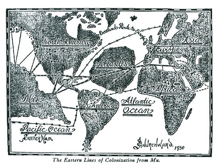
    In the book he claimed that the lost continent of Mu had once extended from an area north of Hawaii southwards as far as Fiji and Easter Island. According to Churchward, Mu was the original Garden of Eden and a technologically advanced civilisation which boasted 64,000,000 inhabitants. Around 12,000 years ago Mu was wiped out by an earthquake and submerged beneath the Pacific. Apparently Atlantis, a colony of Mu, was destroyed in the same way a thousand years later. All the world’s major ancient civilisations, from the Babylonians and the Persians, to the Maya and the Egyptians, were the remains of the colonies of Mu.

    Churchward claimed he received this sensational information when, as a young officer in India during a famine in the 1880s, he became friendly with an Indian priest. This priest told Churchward that he and two cousins were the only survivors of a 70,000 year old esoteric order which originated on Mu itself. This order was known as the ‘Naacal Brotherhood’.

    The priest showed Churchward a number of ancient tablets written by the Naacal Order in a forgotten ancient language, supposed to be the original language of mankind, which he taught the officer to read. Churchward later asserted that certain stone artefacts recovered in Mexico contained parts of the ‘Sacred Inspired Writings of Mu’, perhaps taking ideas from Augustus le Plongeon and his use of the Troana Codex to provide evidence for the existence of Mu.

    Unfortunately, Churchward never produced any evidence to back up his exotic claims, he never published translations of the enigmatic Naacal tablets, and his books, though they still have many followers today, are perhaps better read as entertainment than factual studies of Lemuria / Mu.

    Nan Madol

    It was James Churchward who first posited the theory that the site of Nan Modal, on Pohnpei Island in the North Pacific Ocean, was one of the seven cities of ancient Mu / Lemuria.

    The cyclopean ruins of Nan Modal, at one time a ceremonial centre covering 11 square miles, consist of around 90 small artificial islands built up out of a lagoon, and interlinked by a network of tidal canals. These islands, situated on the tidal flats southeast of Temwen Island, Micronesia, contain house foundations, sea walls – thirty feet tall in places, tunnels and burial vaults, all constructed entirely from prismatic basalt columns stacked crisscross like log cabins. These rocks weigh several tons on average, with the largest weighing 25 tons.

    What makes the construction all the more remarkable is that the stone had to be transported some distance to the site, as no quarries have been found nearby, though they do exist elsewhere on the island. A clue to how this feat was achieved are crystal basalt columns discovered at the bottom of the lagoon near Temwen Island and on the shores of other islets in the area, which would suggest that the stones were transported by raft.

    Modern Pohnpeians, on the other hand, believe the stones were flown over the island using black magic. Radio carbon dates and analysis of pottery from Nan Madol reveal that construction of the site began around 1200 CE, though the area may have been occupied from as early as 200 BCE. Such dates would certainly preclude any connection with Churchward’s Lemurians or their descendents.

    At the beginning of the 13th century CE the island of Pohnpei is thought to have been conquered and unified by the mysterious ‘saudeleur’ dynasty, and it was then that the spectacular complex was constructed as a ceremonial and political seat for the new royal line. The saudeleur line was brought to an end in the 1500s by exiled Pohnpeian warrior, Isokelekel. The new chiefs, known as Nahnmwarki, occupied Nan Madol for a couple of hundred years, but by the 1800’s when the first Europeans arrived, the site was deserted. Why this happened remains one of the many mysteries of this incredible site.

    The Kerguelen Continent

    In the last twenty or so years submerged civilisations have once again been in the news due in particular to a number of intriguing underwater discoveries. In 1999 the Joint Oceanographic Institutions for Deep Earth Sampling (JOIDES) Resolution research vessel made an amazing discovery drilling in an area of the southern Indian Ocean about 3,000 km to the southwest of Australia.

    The researchers discovered that an underwater plateau about a third the size of Australia, known as the Kerguelen Plateau, was actually the remains of a lost continent, which sank beneath the waves around 20 million years ago. The team found fragments of wood, a seed, spores and pollen, in 90 million year old sediment, as well as types of rocks associated with explosive volcanism.

    One of the many fascinating points about the Kerguelen Plateau is that it contains sedimentary rocks similar to those found in India and Australia, which indicates that they were at one time connected. Scientists believe that around 50 million years ago, the continent may have had tropical flora and fauna, including small dinosaurs. With further research planned, the fascinating puzzle of the Kerguelen Plateau may yet resurrect the Lemuria debate.

    Yonaguni Island and the Gulf of Cambay

    In 1985 off the southern coast of Yonaguni Island, the westernmost island of Japan, a Japanese dive tour operator discovered a previously unknown stepped pyramidal edifice. Shortly afterwards, Professor Masaki Kimura, a marine geologist at Ryukyu University in Okinawa, confirmed the existence of the 183m wide, 27m high structure.

    This rectangular stone ziggurat, part of a complex of underwater stone structures in the area which resemble ramps, steps and terraces, is thought to date from somewhere between 3,000 to 8,000 years ago. Some researchers have suggested these ruins are the remains of a submerged civilisation – and that the structures represent perhaps the oldest architecture in the world. Connections with Lemuria and Atlantis have also been mentioned.

    However, some geologists, such as Robert Schoch of Boston University, and others with knowledge of the area, insist that the underwater ‘buildings’ are natural, mainly the result of ocean erosion and coral reef settlements and similar to other known geological formations in the region. Furthermore, archaeologists also point out that no man-made tools or weapons have been recovered from the site, which would indicate human settlement.

    In December 2000 a team from the National Institute of Ocean Technology (NIOT) claimed to have discovered the remains of a huge lost city 36 metres underwater in the Gulf of Cambay, off the western coast of India. A year later further acoustic imaging surveys were undertaken and evidence recorded for apparent human settlement at the site, which included the foundations of huge structures, pottery, sections of walls, beads, pieces of sculpture and human bone. One of the wooden finds supposedly from the city has given a radiocarbon date of 7500 BCE, which would make the site 4,000 years earlier than the oldest known civilisation in India.

    Research is ongoing at this fascinating site, now known as the Gulf of Khambat Cultural Complex (GKCC), which if the dates are proved correct, may one day radically alter our understanding of the world’s first civilisations. However, it must be added that a number of marine geologists believe that the NIOT scientists have made serious errors in their interpretations of the sonar images obtained from the area. The opinion of these researchers is that the supposedly ancient ‘ruins’, shown as geometric patterns on the images, are natural rock formations and there is no evidence that the artefacts discovered in the area of the site, including the radio-carbon dated block of wood, are associated with it. The debate is still continuing among geologists, archaeologists and historians on this controversial discovery.

    Whether any of these underwater finds in the Pacific and Indian Oceans prove to be the remains of forgotten civilisations or not, one thing is certain man will always be searching for a lost homeland or a more spiritually satisfying ancient past. In this sense Lemuria or Mu will always be more than just a physical place.

    [alert type=”general” dismiss=”no”]This article was published in New Dawn 103.[/alert]

    [alert type=”success” dismiss=”no”]If you appreciate this article, please consider subscribing to help maintain this website.[/alert]

    Sources and Further Reading

    The Lost Continent of Mu by J. Churchward, C.W. Daniel Co. Ltd, 1994 (1931).
    The Lost Land of Lemuria: Fabulous Geographies, Catastrophic Histories by Sumathi Ramaswamy, University of California Press, 2005.
    The Secret Doctrine II – Anthropogenesis by H.P. Blavatsky,  Theosophical University Press, Pasadena, California, 1970 (1888).
    Other Temples, Other Gods: The Occult in Australia by N. Drury & G. Tillett, Sydney, Hodder & Stoughton, 1982.
    http://news.bbc.co.uk/2/hi/science/nature/353277.stm ‘Lost Continent Discovered’. The Kerguelen discovery.
    www.hinduonnet.com/fline/fl1905/19050670.htm ‘Questionable Claims’. The finds in the Gulf of Khambat.
    www.morien-institute.org/yonaguni.html Morien Institue page about Yonaguni.
    www.pohnpeiheaven.com/nanmadol.htm ‘Pohnpei Between Time and Tide’.
    www.uoregon.edu/~wsayres/NanMadol.html Dr. William S. Ayres’s site about his work in Nan Madol.

    © New Dawn Magazine and the respective author.
    For our reproduction notice, click here.